COVENTRY UK
COVENTRY
HomeGeophysicsMASW / VS30 (velocidad de ondas de corte)

MASW / VS30 Testing in Coventry – Shear Wave Velocity for Seismic Site Classification

Evidence-based design. Reliable delivery.

LEARN MORE

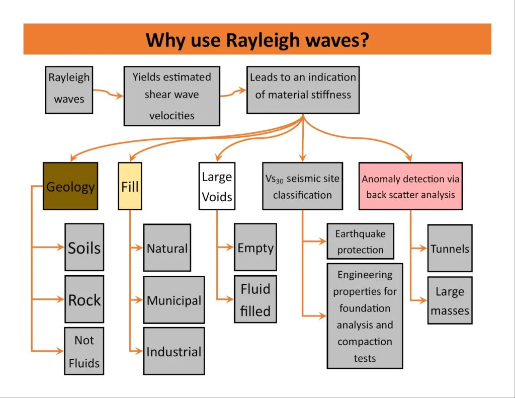
Coventry sits on a mix of Mercia Mudstone and river terrace deposits, with superficial soils often exceeding 10 m in depth and groundwater levels varying seasonally by up to 2 m. These conditions make shear wave velocity profiling essential for seismic site classification under Eurocode 7. We deploy MASW (Multichannel Analysis of Surface Waves) to measure Vs30 directly, avoiding the cost and disruption of borehole-based crosshole surveys. The method works well across Coventry's urban fabric, where traffic and construction noise can challenge other geophysical techniques. Before field acquisition we review existing BGS records to optimise the spread geometry, and we routinely combine MASW with georradar-gpr to map shallow utilities and void hazards that affect wave propagation. The output is a continuous 1-D shear wave velocity profile down to 30 m, classified into ASCE 7 Site Classes A through F.

Illustrative image of MASW / VS30 (shear wave velocity) in Coventry
Direct Vs30 measurement via MASW eliminates the uncertainty of N-SPT correlations in stiff clays and weak mudstones typical of the Coventry area.

Our service areas

Process overview

A common mistake we see in Coventry is relying solely on SPT blow counts to estimate Vs30 for seismic design. The correlation between N-SPT and shear wave velocity is weak in the stiff clays and weak mudstones that underlie much of the city. We recommend MASW as a direct measurement alternative. The survey uses a 24-channel landstreamer with 4.5 Hz geophones spaced at 1 m intervals, and a 7 kg sledgehammer source energised at 10 m offsets. Data processing follows the f-k transform method with dispersion curve inversion using a genetic algorithm – a workflow validated against downhole measurements in nearby Warwickshire. For deep foundations or critical infrastructure we integrate results with ensayo-cpt to cross-check stiffness profiles at discrete depths. Each shot gather is stacked five times to improve signal-to-noise ratio in Coventry's busy urban environment, and we apply a band-pass filter between 5 Hz and 80 Hz to isolate the fundamental-mode Rayleigh wave.
Technical reference — Coventry

Local context

Eurocode 7 (EN 1997-1:2004) and the UK National Annex require site-specific ground investigation for seismic design, but many Coventry projects overlook Vs30 measurement until late in the design stage. The risk is that a building founded on stiff clay over Mercia Mudstone may be classified as Site Class B when in reality the low-strain shear modulus is closer to Class C, leading to under-designed lateral loads. We have seen this issue on several city-centre redevelopments where the original ground investigation only included SPT and basic classification. A MASW survey at feasibility stage costs a fraction of the potential structural retrofit later. The National House Building Council (NHBC) also now recommends Vs30 profiling for all residential developments over three storeys in areas underlain by weak rock, which includes much of Coventry.

Need a geotechnical assessment?

Reply within 24h.

Email: contact@geotechnical-engineering.biz

Reference standards


BS 1377/D4428M-14 (MASW), NEHRP Recommended Seismic Provisions (FEMA P-1050), ASCE 7-16 Site Classification (Chapter 20), BS EN 1997-2:2007 (Eurocode 7 – Ground Investigation)

Technical parameters

ParameterTypical value
Measurement depth30 m (Vs30) or custom depth up to 50 m
Source type7 kg sledgehammer or 40 kg drop weight
Receiver array24 geophones at 1 m spacing
Frequency range5 Hz – 80 Hz band-pass filtered
Output resolution1 m depth increments in shear wave velocity
Site class classificationASCE 7-16 (B, C, D, E, F) / NEHRP

Top questions


What is the difference between MASW and Vs30 from SPT correlations?

MASW measures shear wave velocity directly by analysing surface wave dispersion, while SPT correlations estimate Vs30 from blow counts using empirical relationships that can have errors of ±30% in stiff clays and weak mudstones. In Coventry's Mercia Mudstone, direct measurement avoids this uncertainty and provides a continuous profile rather than discrete point data.

How long does a MASW survey take in Coventry?

A standard 24-channel MASW survey along a single 30 m line takes approximately half a day for field acquisition, including setup, hammer shots, and quality control checks. Data processing and reporting typically take three to five working days. For multiple lines or extended depth surveys, allow an additional day per line.

What site classes are most common in Coventry from MASW results?

Based on our surveys across the city, most sites fall into Site Class B (soft rock) where Mercia Mudstone is near surface, and Site Class C (very dense soil/soft rock) where superficial deposits exceed 10 m. Areas along the River Sowe and Sherbourne valleys can show Site Class D (stiff soil) due to deeper alluvial clays. We have not encountered Class E or F in Coventry.

Location and service area

We serve projects across Coventry.

Location and service area